Once upon a time 10 Indian towns dominated the Bucks County forest.
Vestiges. That’s about all we’re left with. A few arrowheads here. Pottery fragments there. Shards carved from soft stone in other places. They are hints of a thriving Native American civilization that once existed in beautiful Bucks County. In my years researching Bucks, I’ve gained enough insight to sketch out a kind of atlas of the location of 10 Indian towns among many Native American sites:
Kildorpy, Falls Township: An English history published in 1648 indicated this Indian town was near the falls on the Delaware River in present day Morrisville. Colonist Robert Evelin described the town on “clear fields to plant and sow, and near it are sweet large meads of clover and honeysuckle.” No other evidence exists of Kildorpy nor a translation of the name.
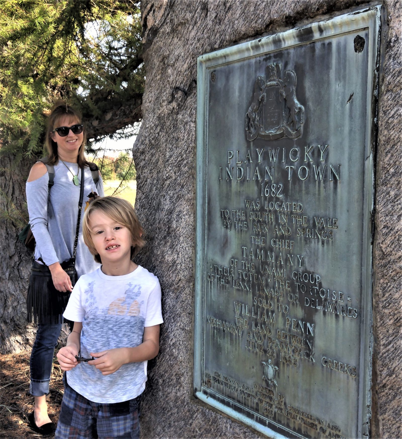
Playwicki, Lower Southampton: A large collection of Lenape Indian relics proves the existence of a major Native American town off today’s Route 213 near where it crosses Neshaminy Creek. Playwicki means “the place full of turkeys where prisoners of warfare were forced to run the gauntley.” The Bucks County Historical Society in 1923 put up a fieldstone monolith with a plaque on the edge of the highway to memorialize Playwicki. Today, the site is Lower Southampton’s Playwicki Farm Park where history and artifacts are preserved and hiking trails proliferate. Lenape Chief Tamanend sold the tract to William Penn in 1682.
Pemipacka, Warminster: On a tributary of Pennypack Creek in Warminster near the Montgomery County border was the Indian town of Pemipacka – translated as “bear-fat creek”. It was a favorite Indian hunting ground for bears for their high energy fatty meat.
Hollekonk, Buckingham: Nestled in Buckingham Valley at the western base of Buckingham Mountain was the Indian town of “Hollekonk”. Lenape Indians drew water from a natural spring located there in a field on today’s Barley Sheaf B&B estate off Route 202. Geologic forces created Hollekonk when the roof of an underground river collapsed. There is evidence the last group of Lenape Indians to leave Bucks for Ohio in 1775 did so after gathering at the spring. Tribal leader Isaac Still left with the men, women and children heading west “far away from war and rum,” as he put it on the eve of the American Revolution. Hollekonk (also known today as Holicong) defies any Indian translation.
Lahaskeke, Buckingham: Located about 3 miles north of Hollekonk on the border between Buckingham and Solebury was the town of Lahaskeke – translated as “the place of much writing”. It’s known today as Peddler’s Village on Route 202. Lahaska Creek arises there and flows south to Neshaminy Creek.
Paunakussing, Solebury: This once vibrant Indian town is today’s picturesque village of Carversville. Colonial settlers jettisoned the name Paunakussing for Milton in reference to several mills founded along what is today Paunaucussing Creek. Milton officially became Carversville when the first post office opened there under postmaster Thomas Carver. Paunakussing in Indian dialect means “where the powder was given to us.”
Tuckwimensing, Solebury: Today’s Solebury Village was once the site of Tuckwimensing, meaning “at the place of the trees of round nuts.” Walnut trees, that is. Many artifacts of Native American society have been recovered there. The sale in 1702 of 250 acres to William Croasdale “at Tooqueminsey in Soulbury Township” verifies the Indian town existed.
Gattalosso, Solebury: In a meadow off Aquatong Road was this Indian town at the headwaters of today’s Cuttalossa Creek. The creek carves its way through a spectacularly steep gorge framing fertile bottom lands and Colonial-era homes before emptying in the Delaware River at the closed Cuttalossa Inn on Route 32 (River Road) below Lumberville. English settlers were completely baffled about how to spell the name of the Indian town. Variations include Quatielassie, Quetyelassy, Quotylossey, Cutelausse and Cuttelassey before finally settling on Cuttalossa – for the creek.
Winnahawchunick, Solebury: There was yet a fourth Indian town in fertile Solebury. Winnahawchunick was located where Pidcock Creek joins the Delaware River in today’s upper section of Washington Crossing Historic Park. The site is better known today as the location of the Thompson-Neely House and grist mill beneath Bowmans Hill. Winnahawchunick is translated as “at the hill near the water.” It’s long been suggested a monument be erected at the site to memorialize the Indian town but no action has been taken.
Pechoqueolin, Nockamixon: This was the largest Indian town in Bucks County based on a vast number of Native American relics discovered at the aboriginal site. Located just below the Durham Township border at the creek’s mouth on the Delaware River, Pechoqueolini translates as “at a gap through the mountains.” High cliffs on both sides of the river exist in the area. Among the artifacts found by archeologists are polishing stones, grooved axes, celts, knives, pestles, hoes, drills, ceremonial hatchets, pottery fragments and amulets.
***
Sources include “Place Names in Bucks County Pennsylvania” by George MacReynolds published in 1942, and the Gallows Run Watershed Association found on the web at www.gwrabucks.org. Also appreciation to Lenne Lenape tribal advocate and descendant Julie McCormick who assisted me long distance from her home in Olympia, Wash. A museum devoted to Lenape culture and a re-created tribal village exist at the Churchville Nature Center in Northampton. Information: www.churchvillenaturecenter.org or call 215-357-4005.