Stories behind Bridge Valley, Little Italy, Smoketown, Rich Hill, Bucktoe and Route 666.
My college roommate and I decided one summer to drive from the University of Florida in Gainesville to meet friends in Yosemite. We were Appalachian Trail hikers and cave divers who enjoyed adventure. So we packed Jim’s new Datsun-Z sports car and headed for California. After motoring across Texas, we jumped on Route 66 and stopped for lunch at a Mexican cantina in Gallup, N.M. The owner suggested we take a side trip on “the Devil’s Highway”. Huh? It’s a connecting road off Route 66 known in earlier times as the Navajo Trail. In 1931 the feds decided a number was needed – Route 666. It wasn’t long before someone declared “666″ is the “number of the beast” (or Antichrist) in the Bible. The 200-mile-long highway suddenly became “cursed”. Quite the contrary to us. Our journey with the convertible top down was spectacularly beautiful through Navajo towns like Yah-ta-Hey and New Mexico’s copper mining district to the edge of the Grand Canyon and then on to Winslow, Ariz. (There I caught the eye of a girl slowing down in her flatbed Ford to take a look at me. Or was it Jim?)
Place names like Devil’s Highway always have been a lure to me. They can lead to adventure, hint at historical tales and reveal vanishing sights. Back here in Bucks, a county as old as ours is no exception. Here’s a sampler of what my daughter, grand kids Dashiell and Margaux and I have visited:
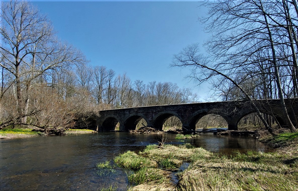
Bridge Valley
This is an area of great scenery on Neshaminy Creek in Warwick near the Buckingham border. A uniquely beautiful 8-arch stone bridge built by county government on York Road in 1795 defines the creek valley. In olden times, the river span was a centerpiece amidst wide, luxurious meadows hugging the stream and carpeting with wildflowers a steep, half-mile-long hill paralleling the creek. These days, the bridge is closed to traffic. Its abutments suffer the ravages of time but the macadam fill is open to pedestrians. Old York Road ends at the bridge with a small parking area from where you can wander along the stream and enjoy the scenery, especially the ancient archways.
Little Italy
In the 19th century, there were low paying jobs that required hard labor. Rock quarrying and building railroads come to mind. In Bucks County, both were centered around a tiny Wrightstown village founded by immigrant Italian laborers. Little Italy today contains a half-dozen homes situated in a ravine between a working rock quarry, Mill Creek and the New Hope & Ivyland Railroad (which the Italians built) just below Wycombe. A one-lane, cement bridge over Mill Creek links the village to Mill Creek Road and the outside world.
Bucktoe and Chickenfoot
In Lower Bucks, two intersections are named after animals. Bucktoe is the connection between Bridgetown Pike and Langhorne-Yardley Road in Middletown near Core Creek Park. As local historian Clarence King points out, the two highways seen from above come together in the shape of a deer’s toe. That’s similar to how Chickenfoot got its name for a 5-way intersection in Levittown where North and South Oxford Valley Road, East and West Woodbourne Road and Wistar Road join. As Clarence put it, “Those old timers had names for many intersections and they all knew them and used their names.”
Smoketown
More than 100 years ago, the settlement of Smoketown existed on Old Bethlehem Pike (Route 309) near Sellersville. Today it’s known as Rocky Ridge. But back then most people knew it as smoketown and not because of smoke curling up from log cabin chimneys. At the time, it was a hangout for Upper Bucks politicians and served as the “up county” rallying point in political campaigns. Many political meetings in smoke-filled rooms gave the area its original name.
Rich Hill
Not far from Rocky Ridge (i.e. Smoketown), is Rich Hill. Some time after the American Revolution, locals called it Bunker Hill after the famous Battle of Bunker Hill near Boston. When a post office opened in the late 1800s, a name change was needed to avoid confusion. Bunker Hill had been taken by a town near Harrisburg. Drat! Local folks scratched their heads together and came up with Rich Hill. After all, the village was on a hill on Rich Hill Road in Richland Township. Logical. Where did those names come from? The first European settlers named them after extraordinarily fertile land first cultivated by Native Americans.
About the Devil’s Highway . . .
Route 666 in New Mexico has gotten a name change. New Mexican Gov. Bill Richardson led the campaign in 2003. People were afraid to drive the highway because of the devil connotation. So now it’s officially Route 371. Politicians believe the name change has boosted tourism and investment. Amazing how “curses” go away with a name change.
Sources include “Place Names in Bucks County History” by George MacReynolds published in 1942 by the Bucks County Historical Society, and “U.S. 666: ‘Beast of a Highway’?” on the web at https://www.fhwa.dot.gov/infrastructure/us666.cfm