How a massive flood transformed life on Morrisville’s river island.
A favorite passion of mine is biking the 60-mile-long Delaware Canal towpath between Bristol and Easton. Occasionally my grandchildren Dashiell, 10, and Margaux, 7 with their parents join in. It’s pandemic social distancing with fun.
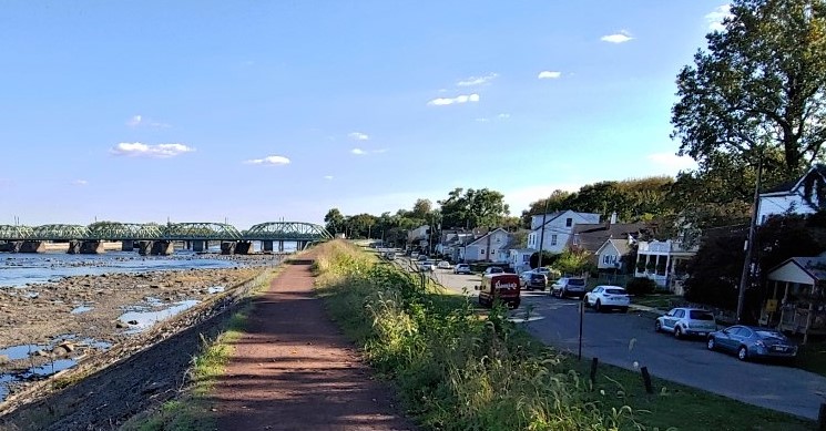
An offshoot trail I never had experienced until recently is the one atop Morrisville’s levee The massive dike built in the 1930s is oldest in Pennsylvania, designed to protect the borough’s lowlands from catastrophic Delaware River flooding. The mile-long clay trail stretches from the Calhoun Street Bridge to the “Trenton Makes” Free Bridge. Both spans offer pedestrian crossings to downtown Trenton. From levee heights you look down on rapids separating the river’s salt water estuary from its fresh water stream from upstate Pennsylvania and New York. The view is magnificent including the golden dome of Trenton’s state capitol.
Periodic flooding occasionally swamped a habitable place called “The Island” in Morrisville. A wing-dam funneled river water into a fast-flowing side channel of the river hugging Delmorr Avenue from the Calhoun Street Bridge to just below the “Trenton Makes” bridge where it rejoined the river. In Colonial times, the channel powered grist mills, making the acreage valuable when George Washington was skulking about town with his Continental Army contemplating his famous crossing the Delaware to overrun Hessian soldiers occupying Trenton for the British in 1776.
By the 19th century, citizens had constructed riverside homes on the island. Life was blissful – until the river flooded. One of the most damaging occurred in March 1904 when the Delaware crested at 30 feet. Not to be denied, property owners rebuilt. After all, flooding of that nature was rare. In 1930 state officials proposed a 32-foot-high levee to protect the island. Islanders weren’t happy. It would destroy their view. With the trade-off of property protection, preparatory work got underway. Earth fortified with layers of stone called rip-rac would ensure the levee’s longevity.
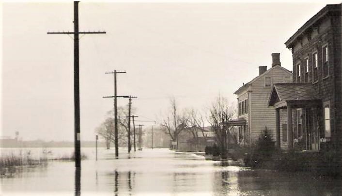
By that time levees were a dire necessity in low lands along Pennsylvania’s 45,000 miles of rivers and streams where much of the state’s population lived. That became clear on March 9, 1936 when rain began falling widely across the Northeast. Back-to-back storm systems brought a deluge over two weeks. It was the most intense drenching in history. Fast melting winter snow added to the catastrophe. “Billions of tons of water poured into farmhouses, villages, towns and large cities,” according historian Joseph Arnold of the U.S. Army Corps of Engineers. More than 82,000 buildings were destroyed or damaged including 38,000 homes like those on Morrisville’s island. At dawn on March 22, the view from Delmorr Avenue was a raging inland sea drowning the island and work on the levee. The flood stretched a half mile into downtown Trenton where the torrent crested at 25 feet.
The disaster convinced Congress to do something. What emerged was the Flood Control Act of 1936 authorizing the Corps of Engineers to build hundreds of miles of levees, flood walls and 375 major reservoirs in the U.S. plus rerouting river channels. The breath-taking scope of the legislation rivals only the construction of the interstate highway system of the 1950s. Workers completed Morrisville’s levee in 1939. Sixteen years the greatest flood in modern history ravaged the river basin. Remnants of two hurricanes stalled over the basin for two weeks in August 1955. Entire homes floated down river, knocking out bridges in Yardley and Point Pleasant. Army and Navy helicopters rescued Boy and Girl Scouts trapped at camps on Treasure, Marshall and Pennington islands in Upper Bucks. The flood submerged the Bucks County Playhouse in New Hope and turned Yardley into “a watery terror, abject and awesome,” as one eyewitness put it.
In Morrisville the levee held. The island by then was part of mainland Morrisville, the river channel long gone. Much of the acreage had become Williamson Municipal Park with a swimming pool and ballfield, home to the Morrisville Little League that won the World Series in 1955.
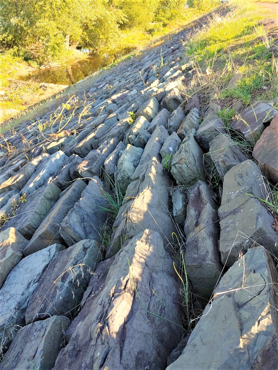
The levee lately is showing its age. Cracked concrete, silt accumulation, missing rip-rac, soil erosion and vegetation have taken a toll. Borough government is in the midst of a restoration effort while considering a $125 million redevelopment of the island. If successful, retail shops, restaurants, a boutique hotel, grocery store, 500 luxury apartments built into 5-story buildings and an amphitheater will replace the parkland. A public hearing on those plans is expected in December.
In the meantime, a stroll on the footpath remains a delight. You pause and take in an incredible tableau of Morrisville history, a town where the local banker financed the American Revolution, where Gen. George plotted his famous attack on Trenton and where the small borough nearly became the new nation’s capital in 1783. Historical markers on the levee noting this would be welcome.
***
Sources include “The Evolution of the 1936 Flood Control Act” by Joseph L. Arnold published by the U.S. Army Corps of Engineers in 1988; Bucks County Flood Recovery and Mitigation Strategy” published by Delaware Valley Regional Planning Commission in 1998 and “Two hurricanes a week apart – the disastrous 1955 flood” by Jerry Jonas published on Aug. 3, 2015 in the Bucks County Courier Times and The Intelligencer. Plans for the island redevelopment can be found on the web at http://www.sikora-wa.com/news/2020/11/20/williamson-park-town-center.